
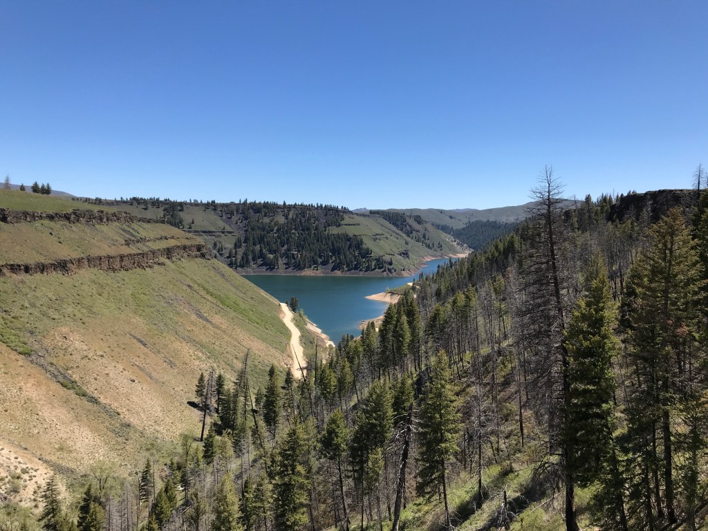
While most Boiseans are familiar with our local reservoirs, Lucky Peak and Arrowrock, a surprising number haven’t made the trip to nearby Anderson Ranch Reservoir. Only 20 miles northeast of Mountain Home, where the sagebrush hills meet the forested mountains of the Trinity and Boise Ranges, the lake is held back by an earth rockfill dam that was the tallest of its kind in the world when completed in 1950. While it’s calm waters and shady grounds may be more popular with boaters and campers, there is plenty of good hiking along the reservoir, including the Wilson Flat Loop, which has quickly become a new favorite of mine. If you’re seeking a moderately challenging and beautiful eight-mile loop less than an hour and a half from Boise, this trail will sate you.
On the Trail
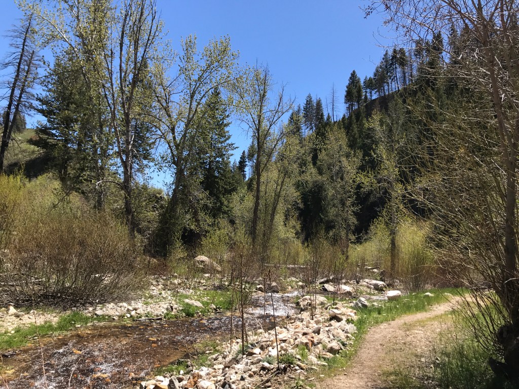
The trailhead is located at the inlet where Wilson Creek tumbles into the reservoir. For 0.6 miles, the trail meanders along the creek, which is well-shaded by cottonwoods and pines and lined with bushes and wildflowers. Here, hundreds of butterflies floated around us in mid-May 2022. There are creek crossings at 0.4 and 0.5 miles, both of which are shallow enough to walk through in high-top boots. There are strategically placed rocks and logs for those intending to stay completely dry. At the first crossing, we saw a large trout attempting to spawn up the creek as we traversed it.
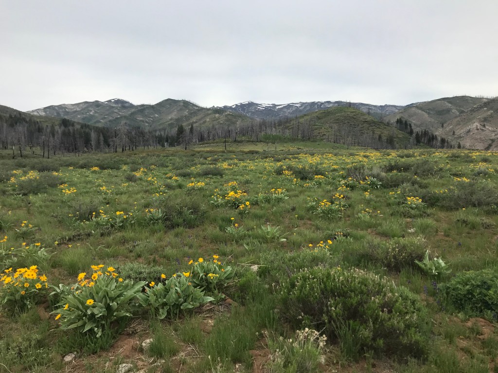
At 0.6 miles, the trail turns 180° and begins a steep ascent to the flat plateau above – hence the name. This is the most difficult stretch of trail, gaining about 400 feet in less than half a mile. However, it is shaded and there are intermittent flat points where you can stop to catch your breath. As you ascend, increasingly excellent views of the reservoir unfold in front of you. At the top, a meadow full of arrowleaf balsamroot extends to the edge of the bluff. Its easy to hike cross-country along this flat, open prairie if you want close-up views of the cliffs and reservoir, as outlined in hike #48 of Scott Marchant’s guide book, The Hiker’s Guide: Exploring Greater Boise.
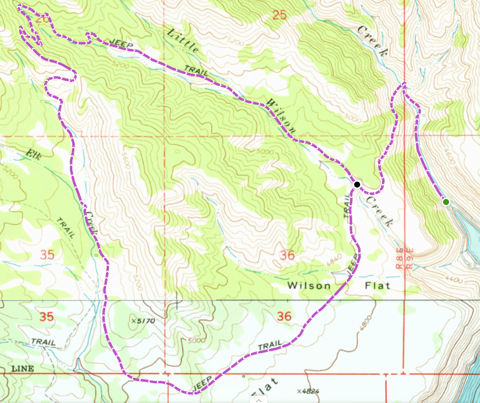
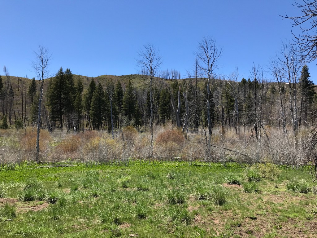
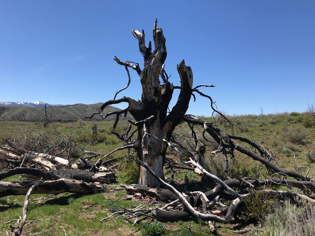
After skirting the edge of the meadow for 0.3 miles, you’ll arrive at the fork in the trail. I’d recommend hiking the loop clockwise, as the elevation gain is more gradual and the views are better in this direction. Taking the left fork, you’ll immediately cross Little Wilson Creek, an easy hop, skip, or jump. The next mile and a half traverses the wide-open terrain of the plateau, gradually ascending to pine stands that the Elk Complex forest fire burned severely in 2013. While trees haven’t yet made a comeback here, bushes, shrubs, wildflowers, and ferns are flourishing in the direct sunlight. Countless birds and rodents have made a home in the contorted super-bloom of plant life.

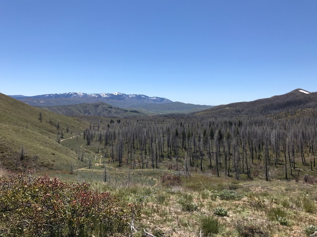
At 2.8 miles from the start, the trail turns north and parallels Elk Creek, re-entering the forest, which is about 90% dead, but still standing. As you ascend, the views of Granite Mountain become more expansive and impressive in front of you. While there isn’t much shade on this stretch, there are some viable campsites along the creek. At 4.2 miles, you’ll enter a series of switchbacks that bring you to the saddle between the Little Wilson Creek and Elk Creek drainages, with superior views in all directions. This is the final and second-most major ascent on the trail, and a good time to re-apply sunscreen.
After a quick traipse along the ridge, you’ll drop into switchbacks towards Little Wilson Creek, where the forest is still alive and thriving. The trail beelines southeast towards the initial trail fork, losing elevation more quickly than you gained it on the outbound leg. Somewhere along this section, approximately six miles into the hike, my hiking party saw a juvenile black bear foraging for berries on the trail ahead of us. After the initial assessment of the situation (Is it young enough to be with a mother? Is it hungry for human flesh? Why did I leave my bear spray cannister at home?), I blew my whistle loudly, yelled, and clapped – it darted off into the forest and wasn’t seen again. We loudly clacked sticks together for the rest of the hike to ward off other potential ursine pals.
At around 6.7 miles, there is a superb campsite just off-trail along the creek. Nestled in a stand of mature pines, it is flat, grassy, shady, and sheltered. Previous convoys left behind several fire rings, good log stumps to sit on, and a teepee structure. If I do return to backpack, this is where I’ll shack up for the night. Just beyond this sublime spot, you’ll ditch the forest for the meadow and converge upon the initial intersection. Head back the way you came, about 1.3 miles back to the trailhead.
Trail Stats
- Season: April to November
- Difficulty: Moderate
- Type: Loop
- Surface: Single and double track dirt
- Distance: 8.2 miles
- Starting elevation: 4,231 feet
- Elevation gain: 1,370 feet
My Rating
While I don’t know if I’d classify this as a “hidden gem,” I don’t think it sees many hikers, and it sure is beautiful. Maybe I’ll call it a “secret jewel” instead, just to avoid the cliché. The only reason I’m deducting half a star is because there are a few places on the trail where you can see homes and ranches across the reservoir, and it diminishes the feeling of isolation that I’m seeking when I go for a hike in the wilderness. The full loop was my second time hiking here, and I’d definitely return a third time.
How to Get There
The route to the Wilson Creek Trailhead takes about an hour and fifteen minutes from Boise and is suitable for all vehicle types, with only a short stretch of dirt roads around Anderson Ranch Dam. Here is the step-by-step navigation from the intersection of Interstate 84 and US-20 in Mountain Home, or use these steps:
- Proceed northeast on US-20 for 20.7 miles
- Turn left onto Anderson Dam Road
- Continue 5.0 miles to the Anderson Ranch Dam crossing
- Turn left and proceed 0.3 miles across the dam
- Turn right to continue on Anderson Dam Road/NF-120
- Proceed 2.0 miles to the trailhead in front of you in the gulch
There is parking for two vehicles at the trailhead gate, with more parking available along the sides of the road and at Little Wilson Creek Campground.
Preparation
Boise National Forest
Mountain Home Ranger District
(208) 587-7961
Interactive Map of Road, Trail, and Area Closures
Here are the need-to-know details for hiking Wilson Flat:
- This is black bear country – carry personal protection and know what to do in an encounter (here is a handy guide from the Humane Society of the United States)
- There are a few water crossings, some of which may be difficult for young children to navigate alone
- The three main creeks, Wilson, Little Wilson, and Elk, are seasonal and not reliable water sources
- Route-finding is not necessary at any point on this trail
- About two-thirds of the trail travels through meadowlands and significantly burned pine forests and is not shaded – protect yourself as needed
- Be respectful to other trail users and Leave No Trace!
Other Useful Resources
- Downloadable GPX route via AllTrails
- The Hiker’s Guide: Exploring Greater Boise by Scott Marchant
- Topographical map via Natural Atlas
