Sometimes it’s difficult for me to write introductions without feeling like these posts are getting repetitive. How many different ways can I ask the reader if they like lakes, forests, and mountains with great views? Do I even need to ask? That’s why you’re reading this, right? Do I really need to introduce this to you? Maybe I’ll switch it up this time… if you HATE pristine lakes, DESPISE the woods, and LOATHE mountaintops entirely, don’t come here. Don’t keep reading – it will only upset you. This trail is too perfect and you would detest the entire experience.

On the Trail
Langer Lake Trail starts at the Langer Monument, dedicated to forest ranger Charley J. Langer, pilot Bill Kelly, and copilot Arthur A. Crofts, who were killed on April 5th, 1943 in a nearby plane crash while conducting a search and rescue mission for survivors of an army bomber that crashed elsewhere in the central Idaho wilderness. Near the marker is a wilderness area permit box – please sign in when entering and out when leaving, then look for the steeply-ascending trail a few steps to the right. The route begins with a fairly arduous climb, gaining 700 feet in a mile, alternating between shade and exposure. Personally, I think it’s great to get a quarter of the overall gain out of the way when your legs are fresh.
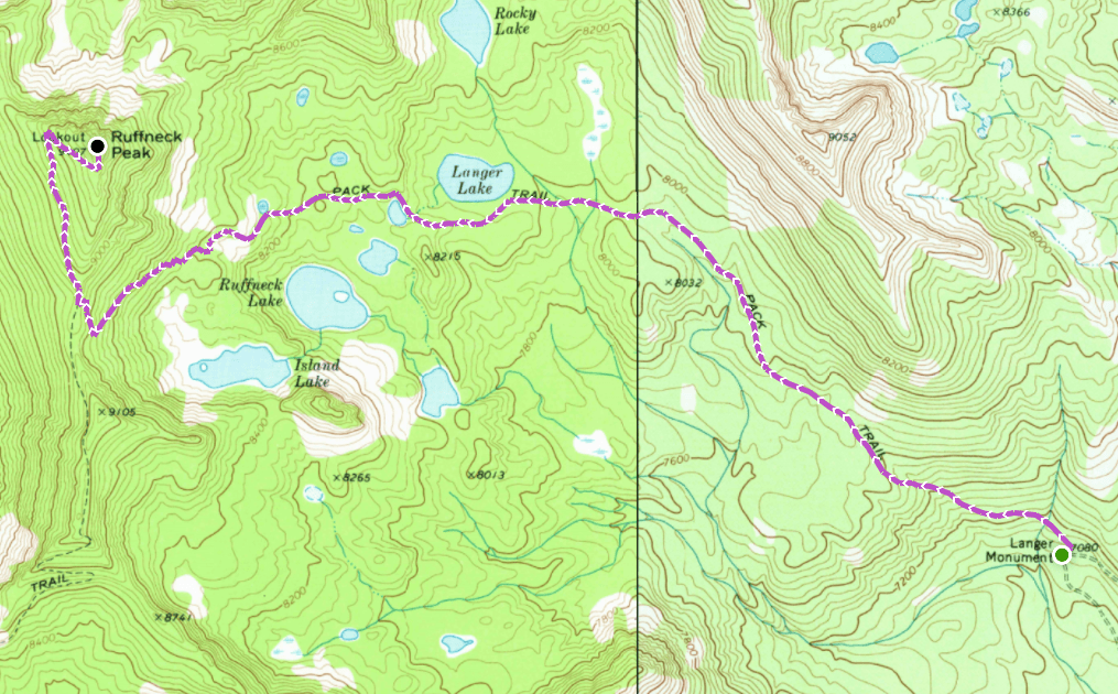
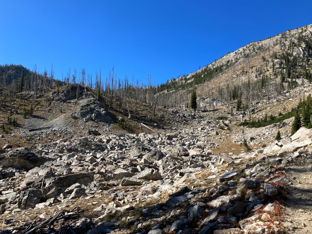
There are a few rough, rocky sections just before the trail levels out on an open hillside where a young pine forest is slowly reclaiming land burned in a 1998 wildfire. Here, you can catch your breath and regroup as views open up all the way to the endpoint – the tiny white speck that is the Ruffneck Peak Lookout Tower. The second mile is relatively flat, traveling in and out of mature pine forest and across two creeks. They’re not bridged, but other hikers have cleverly placed rocks and logs to create crossings.

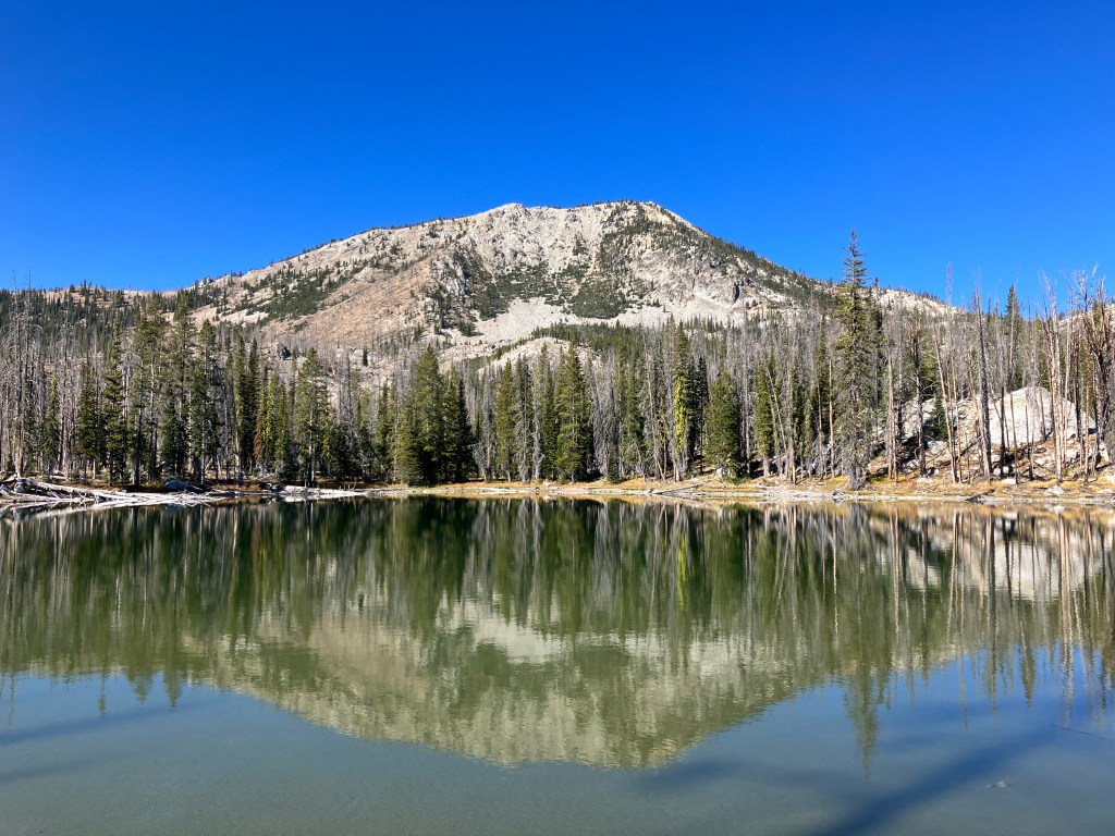
At 2.1 miles, you’ll see the blue surface of Langer Lake reflecting the horizon back at you through the trees. Leave the main trail and walk down to the shore through several excellent campsites. On our visit in early October 2022, it was so calm and quiet that you could only hear your own heartbeat. The lake is framed beautifully by Ruffneck Peak, Langer Peak, and the high ridgeline that rises between them. There is a huge rock (centered below) that I’d wager is fun to jump off in the summer if the water below it is deep enough. If you’re looking to backpack this trail, this is an awesome spot to set up camp, as you could easily do side trips to the lookout tower and several other lakes in the basin. We walked along the southern shore of the lake until the trail disappeared, then hiked cross-country up a draw back to the main trail.
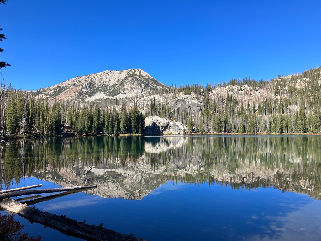
If you stay on the main trail, the intersection for Island Lake is 2.4 miles from the trailhead (it was 3.3 for us due to our detour around Langer Lake). It’s a quick 0.4-miles past an unnamed pond to Island Lake, whose green-tinted waters sit just north of the impressive granite dome pictured below. The 2012 wildfire that blazed through here burned so intensely that it jumped across the lake and consumed the trees on it’s namesake island. Despite this, there are still a few great campsites shaded by the surviving pines. To return to the main trail, retrace your steps to the intersection and hang a left.
A quarter of a mile further up the main trail, you’ll come to an intersection. The trail to the right leads up and over a saddle to the Finger Lakes and eventually Fall Creek. Continue straight/left to stay on the route to Ruffneck Peak. If you need water, the last reliable source to filter from is a small pond coming up on the right. 0.3 miles after the intersection, the trail skirts around a huge rockfall and begins climbing to a high saddle south of the peak. I’d recommend taking a hydration break and eating a snack to prepare for the 700-foot gain ahead of you. This is the most severe burn scar and offers very little shade, so it may be time to re-up on sunscreen too.
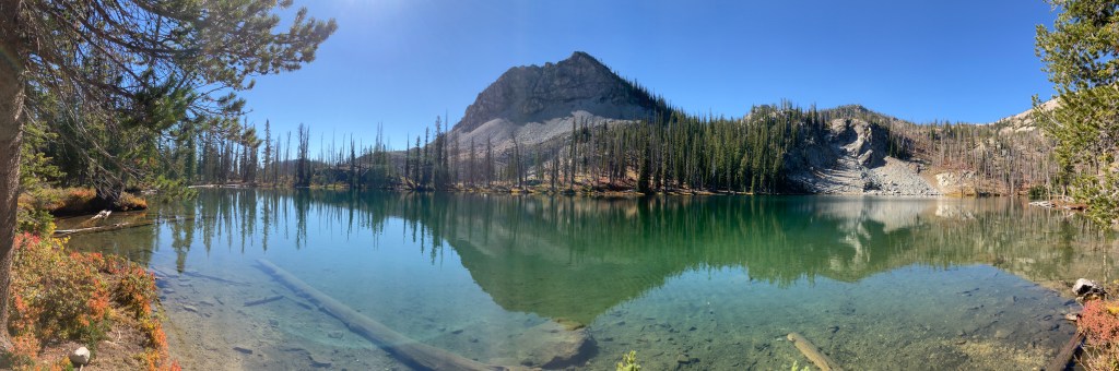
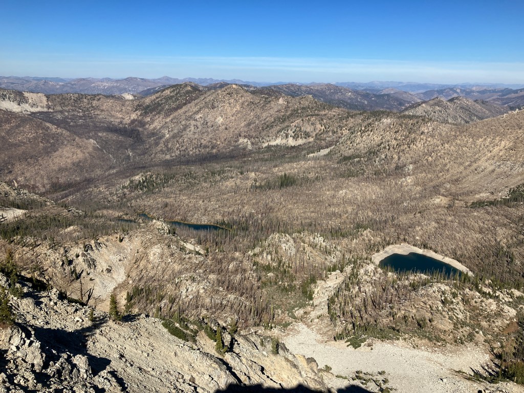
Near the saddle, you’ll traverse a few switchbacks. The elevation gain is relentless, but you’ll be rewarded by ever-improving views of the lake basin and several mountain ranges to the east. As evidenced in the picture below, some of the lakes are seasonal and will be dried up later in the year. Once on the saddle, you’ll be able to see for miles west into the Middle Fork Salmon River drainage as well. When you’re ready for the summit push, continue north on the well-shaded trail to the lookout. The final ascent is much more gradual and will feel easy with the saddle climb behind you.

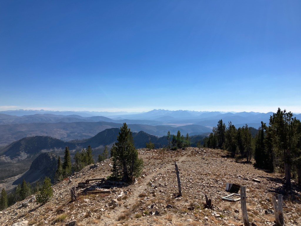
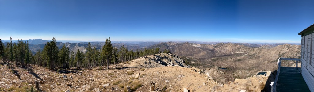
It’s 0.8 miles up and two big switchbacks before the lookout tower comes into view. If you’re visiting during fire season, please be courteous to the ranger stationed here (it’s common for lookout rangers to have canine companions, so don’t be surprised if a big dog greets you first). Our trek was later in the year when the tower had already been shuttered, but we were able to walk onto the deck and enjoy 360° views.

I can’t even describe how incredible the scenery was, and I’ve intentionally excluded the many panoramic pictures I took because I want you to experience it for yourself (and let’s be honest, they don’t do it justice, especially on a phone screen). The number of peaks and lakes visible from the top is absurd and awe-inspiring. Had I known exactly where to look, I’m sure I could’ve pointed out several other lookout towers I’ve visited before. I could’ve stayed up here for hours.
When you’re done taking in the views, retrace your steps all the way back to the trailhead. Be extra cautious on the exposed, steep downhill section from the saddle to the rockfall. If you bypass the lakes on the return trip, expect a distance of about 4.3 miles.
Trail Stats
- Season: June to October
- Difficulty: Strenuous
- Type: Out-and-back, optional spur to Island Lake
- Surface: Single-track dirt and rock
- Distance: 8.5 miles (9.7 with Island Lake)
- Starting elevation: 7,072 feet
- Elevation gain: 2,450 feet (2,560 with Island Lake)
My Rating
Langer Lake Trail was my first foray into the Frank Church-River of No Return Wilderness, and it didn’t disappoint. I’m hoping I can plan another day hike nearby this year before the area is covered in snow. One of my biggest takeaways was just how quiet it was here – when the gentle breeze stopped, there was genuinely no sound, and we didn’t see a single other person all day. This ticked all the boxes of a five-star trail.
How to Get There
Despite it’s location in the largest contiguous wilderness area in the lower 48 states, Langer Lake Trail is a quick 7.2 miles off Highway 21 on high quality dirt roads that any vehicle type can navigate. From Boise, it’s about a 2.5-hour drive, making it a good day trip destination. If you’re coming from Boise or points further west, you can take Highway 21 or 16 to Lowman, depending on which part of the Treasure Valley you’re starting at. Here is the step-by-step navigation from Lowman, or use these steps:
- Continue east/north on Highway 21 for 40 miles
- Turn left onto NF-083/Lola Creek Road
- Immediately turn right onto NF-203/Marsh Creek Road
- Continue 0.4 miles to a four-way intersection
- Turn left onto NF-008/Seafoam Road
- Continue 6.8 miles to a sharp uphill curve in the road – look for a trailhead register on the left (northwest) and parking for 5-6 vehicles on the right
If you’re coming from Stanley or other points north, south, or east, here is the step-by-step navigation from the intersection of Highways 21 and 75, or use these steps:
- Continue east/north on Highway 21 for 18.3 miles
- Turn right onto NF-083/Lola Creek Road
- Follow steps 3-6 above
Preparation
Salmon-Challis National Forest
Frank Church-River of No Return Wilderness
Middle Fork Ranger District
(208) 879-4101
Here are the need-to-know details for hiking to Ruffneck Peak:
- This is black bear country – carry personal protection and know what to do in an encounter (here is a handy guide from the Humane Society of the United States for black bears)
- Three sections of this trail gain elevation arduously and without shade – know your own ability and plan accordingly
- There are two unbridged creek crossings that were still flowing when we hiked here in mid-October 2022 – they may pose a larger obstacle in spring when runoff is higher
- There are numerous sources to pump and filter water from – the last reliable source before the final ascent to the summit is a pond on the north side of the trail 2.7 miles from the trailhead
- Route-finding is not necessary at any point on this trail
- The trails travels sporadically through burn scars from wildfires in 2021 and 1998 – protect yourself from the sun as needed
- Be respectful to other trail users and Leave No Trace!
Other Useful Resources
- Downloadable GPX track via AllTrails
- The Hiker’s Guide: Idaho’s Sawtooth Country by Scott Marchant
- Topographical map via CalTopo
