I didn’t expect to delay my first blog post of 2023 until more than halfway through the year, but our incredibly long and epic winter didn’t relent until mid-May, and its snowy and icy remnants are still clinging in the nooks and crevices of most trails even as summer temperatures crest 100 degrees. I’m not complaining – I got 20 days of skiing in, including Bogus Basin’s latest closing day ever on May 6th, and the typically brown Boise foothills have remained uncharacteristically green throughout the seasons so far. Most of my hiking has been limited to lower elevation trails that aren’t as scenic or noteworthy as I prefer to write about; I did, however, complete the Boise Grand Slam by early June. Shortly after, I opted to repeat one of the four summits from a different trail while revisiting a top-rated Boise hiking landmark, which leads me to today’s post. Keep reading if you’re interested in visiting Adelmann Mine and Lucky Peak in one great 8.5-mile trail!
On the Trail
At the trailhead, squeeze through the unusually narrow chicane and start walking up the gravel road through the Boise River Wildlife Management Area depot. Be courteous to any employees, especially if they’re moving heavy machinery around. The BRWMA spans east-west from Arrowrock Dam to Boise proper and all the way down to the Danskin Mountains at its southern border, conserving 36,000 acres of critical winter habitat for thousands of mule deer and elk. To maintain this safe haven for cervine animals, all dogs must be leashed within the management area.
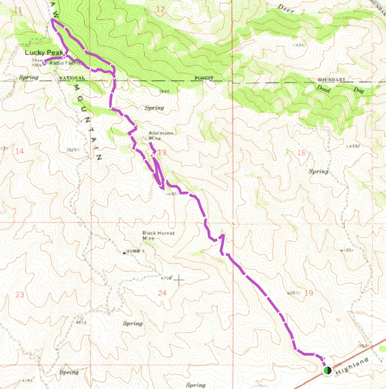
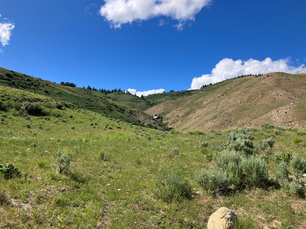
The first mile is relatively nondescript, rising about 400 feet through tall grass and sagebrush. When I hiked this in mid-June 2023, groundwater from the long, wet winter and rain from recent thunderstorms kept the grass lush and vibrant, but this section of the foothills tends to dry out rapidly in average summer heat. The Mormon crickets were a constant interruption, but their numbers didn’t quite approach the near-apocalyptic levels sometimes seen in southwestern Idaho. After one mile, the road crosses over two streams and begins ascending the rocky hillsides quite steeply. I always wonder how vehicles from the mine’s boom era were able to navigate such extreme slopes while I’m pausing to catch my breath.

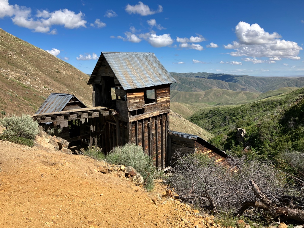
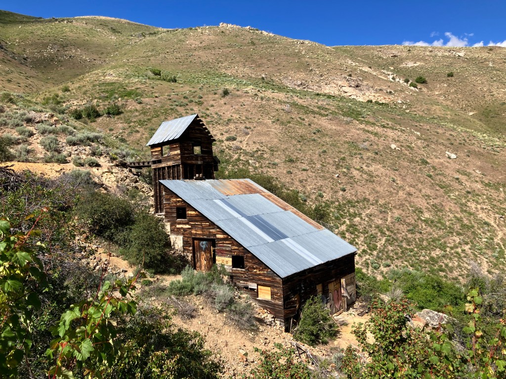
At 1.8 miles, you’ll crest a hill and get a first glance at the main mine building nestled in the gulch ahead. Starting here, the grade gradually tapers off – the steepest part is behind you already. At 2.1 miles, you’ll arrive at an intersection where the spur to the mine splinters from the main trail, and you can choose whether to visit it now, on the way down, or both – I did both because it’s the best place to stop and eat a snack in both directions. Whichever you prefer, it’s a flat, painless quarter mile to the mine with a minor creek crossing that is typically dry by midsummer.
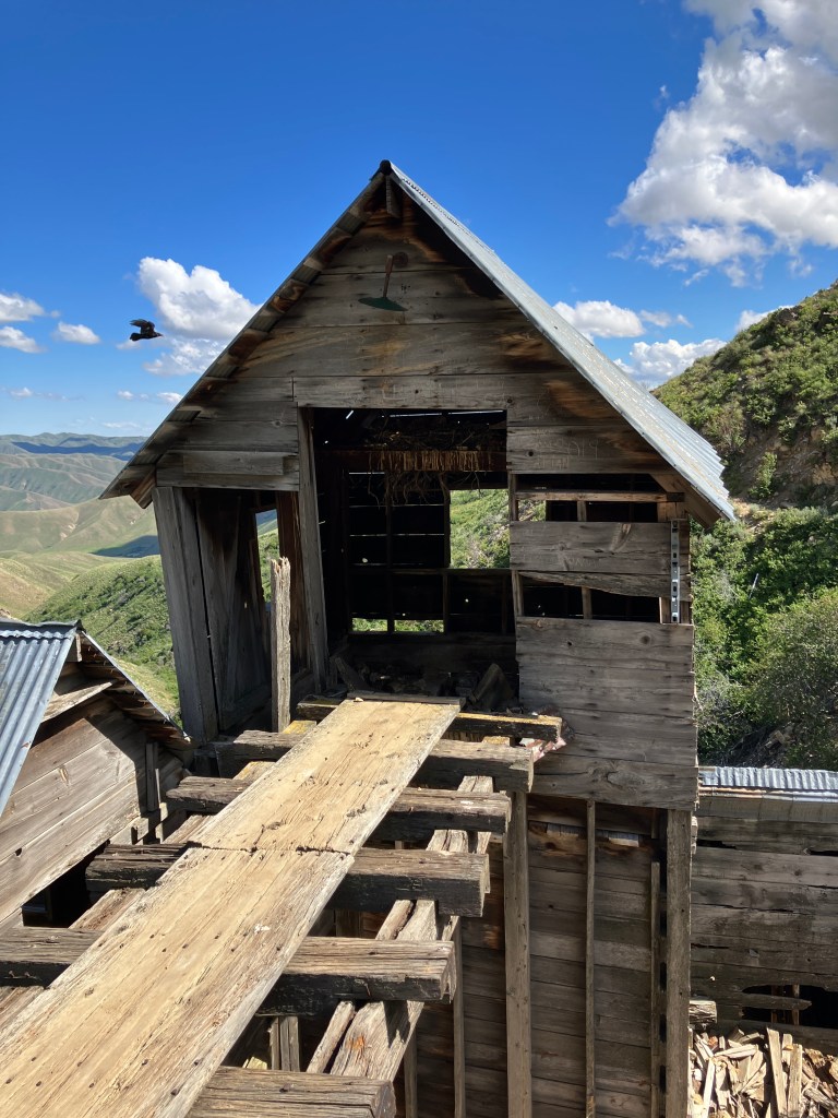
The mine consists of two buildings – one is a warehouse filled with old material and graffiti. The other is the one you’ve seen on Instagram – a picturesque structure reminiscent of the ghost towns and gold rushes of the wild west. It is possible to enter both buildings, but I don’t trust century old carpentry as much as others do. I’d recommend sticking to the trail and adhering to the Leave No Trace principle of “take only photographs, leave only footprints,” especially given that a pair of very territorial ravens were nesting in the belfry-like edifice when I visited. There is a sort of bridge from it to the trail that I would not attempt to walk across under any circumstances – be cautious if you venture near or on it.
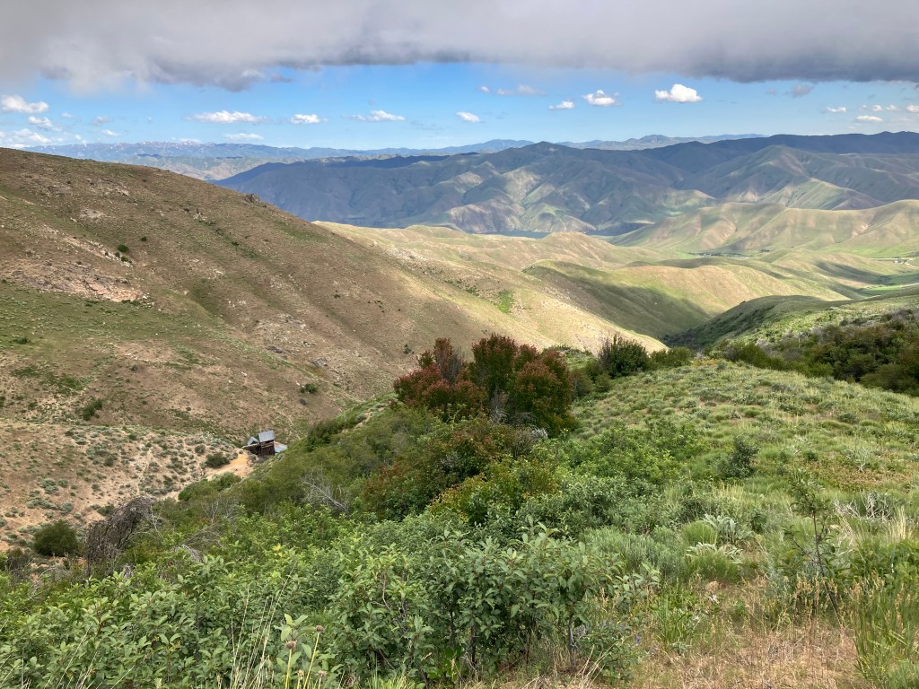
When you’re ready to get back on the trail, head back the way you came to the intersection. Then, instead of going downhill to the left, continue up and to the right on the trail that climbs towards the gate on the ridge. After the gate, the trail hairpins and continues climbing up the side of the hill. The quality of the surface starts to diminish from dirt road to two track. There’s occasional shade from huge snowbrush plants and the quality and quantity of wildflowers both increase. At mile 3.4, you’ll see the mine from above before turning the corner and starting a healthy climb into the pine forest on Lucky Peak’s east slopes.
After 3.5 miles, the trail enters a narrow gulch and becomes much rockier before leveling out in a small meadow. Another small ascent leads to the edge of Lucky Peak’s east ridge, where the forest becomes considerably thicker. Here, the trail widens again to a forest road and flattens out almost completely for just over a half-mile to a gated intersection with the Shaw Mountain Road Trail of the Ridge to Rivers System. The gate is locked to vehicle travel, but there’s a chicane tucked away in the bushes on the left. Hang a left up the rocky trail for the final push to the peak.
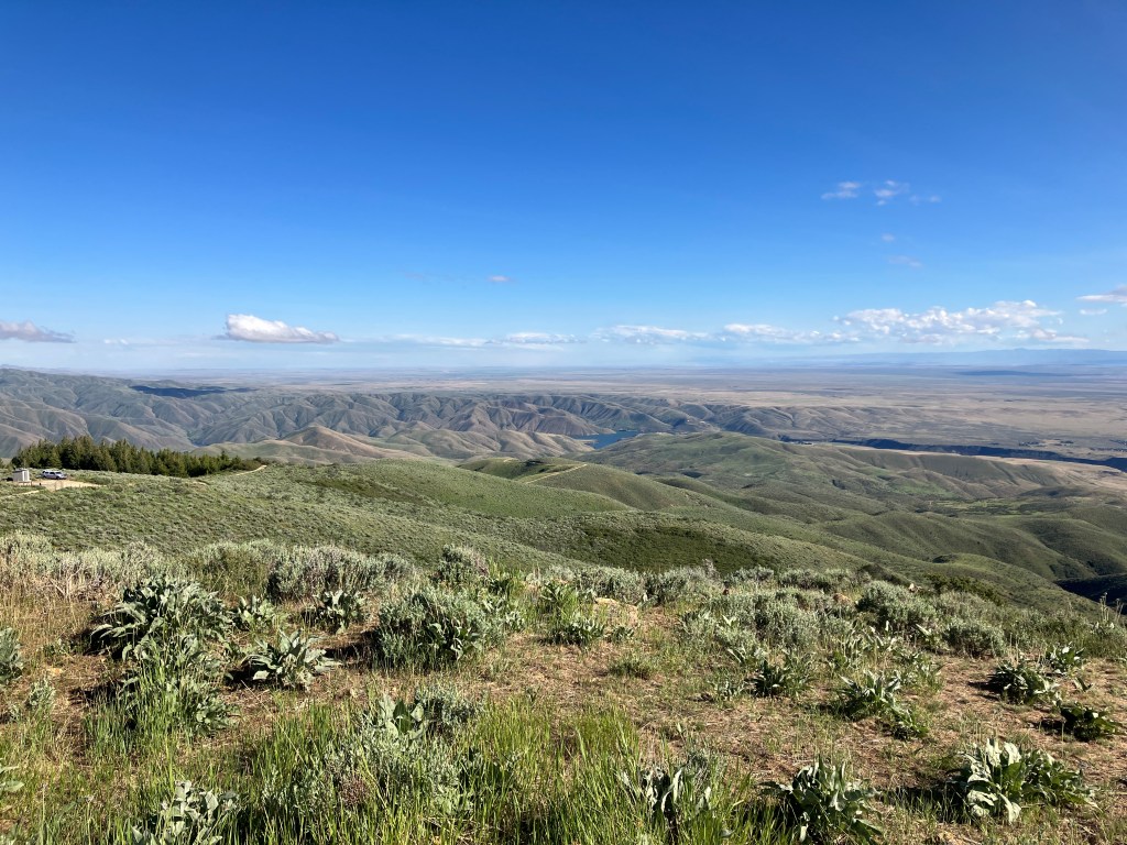
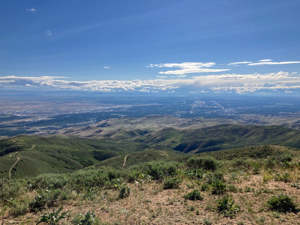
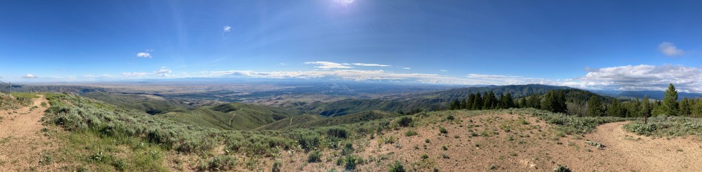
At mile 4.8, you’ll reach a false summit as the Intermountain Bird Observatory camp comes into view ahead of you. If researchers are present, be respectful when passing through. The trail then curves up to the 5,904-foot summit, which has several survey markers and a radio tower. It’s my personal opinion that the best views of Boise and the Treasure Valley are seen from here, especially in the evening when the sun starts to set. Next time I hike this trail, I’ll bring a lunch and plan on eating it here.

My recommended return route is slightly different, utilizing a superb single-track trail that I don’t see listed on any other hiking or mountain biking site. To find it, retrace your steps to the false summit opposite the IBO camp. When the trail turns north, look for two wooden steps on the right (east) – turn onto this minor trail, which travels up and over a small hill before descending into a wildflower-ridden section of forest filled with serenading songbirds. While this route is a little overgrown, it makes up for it with serenity and beauty. Once you reach the intersection with the main trail, head south and downhill back to the mine and the trailhead.
Trail Stats
- Season: April to November
- Difficulty: Moderate to hard
- Type: Out-and-back with spur and end loop
- Surface: Dirt road, dirt/rock two-track, dirt single track
- Distance: 8.4 miles
- Starting elevation: 3,627 feet
- Elevation gain: 2,350 feet
My Rating
I’d hiked both the main Lucky Peak Loop and Adelmann Trail before, but didn’t know there was a trail connecting both of them until recently. I rate both of those trails highly, and this twofer proved exceptionally fun and interesting, without feeling too hard. I was pleasantly surprised at how beautiful the upper section to Lucky Peak was, especially the hidden single-track trail that descends from the summit back to the old forest road. I’d do it again and would highly recommend it to anyone that hasn’t bagged Lucky Peak or been to Adelmann Mine yet.
How to Get There
Here is the step-by-step navigation from the intersection of Interstate 84 and ID-21 in southeast Boise, or use these steps:
- Continue east on ID-21 for 9.8 miles to Highland Valley Summit
- After passing Hilltop Station and starting downhill, slow down and look for a brown sign on the right that says “Info” and “Boise River Wildlife Management Area” with an arrow pointing to the left
- Turn left and park in the gravel lot outside the gate – there is only room for about eight vehicles
Because of the limited parking and popularity of this trail, it may be necessary to parallel park on the shoulder of Highway 21. If you do, please be cautious when walking along the highway to and from your vehicle.
Preparation
Boise River Wildlife Management Area
Boise Front Segment
(208) 465-8465
Here are the need-to-know details for hiking to Lucky Peak on Adelmann Mine Trail:
- This is black bear country – carry personal protection and know what to do in an encounter (here is a handy guide from the Humane Society of the United States for black bears)
- For your own safety, do not enter the buildings or walk across any of the mine structures
- Wear sturdy hiking shoes or boots for the rocky sections of trail
- Bring your own water – there is no reliable water source in the area
- There is no shade on the first three miles of trail – protect yourself from the sun as needed
- Route-finding is not necessary at any point on this trail
- Be respectful to other trail users and Leave No Trace!
Other Useful Resources
- Downloadable GPX track via AllTrails
- Topographical map via Natural Atlas

One response to “Lucky Peak via Adelmann Mine Trail”
[…] © hikingboise […]
LikeLike