I try not to use superlatives excessively when describing trails, scenery, and experiences, but every once in a while, I hike a trail that is definitively “the best” in a certain category. I’m delighted to report that last weekend, I found another one. Box Lake Trail, located just fifteen miles northeast of McCall, has the most wildflowers I’ve ever seen on a single hiking trail – and it isn’t close. While I also try to avoid travel blog clichés in my posts, I’m going to designate this trail a “must do” for any hikers visiting Boise or McCall. If you like frolicking through forests of fireweed, galloping in grasslands of gentian, or promenading past prairies of paintbrush, add Box Lake to your list.
On the Trail
I’ll provide a quick disclaimer here – if you come here looking for wildflowers, know that each year is different, and many factors contribute to when and how wildflowers bloom (here’s a nice article from Joshua Tree National Park explaining some of them). It was unexpected for us to see so much vibrancy this late in the year, considering we hiked Box Lake Trail on August 12th, but my understanding is that the atypically long and wet winter and spring, combined with lower-than-average summer temperatures and absence of wildfires, wind, and smoke allowed the wildflower growth to climax when we visited. If you’re planning a trip, consider those factors and check available resources like AllTrails reviews or the Payette National Forest Ranger Stations to gauge whether it’s blooming season (or feel free to reach out to me, my socials are linked on my About Me page).
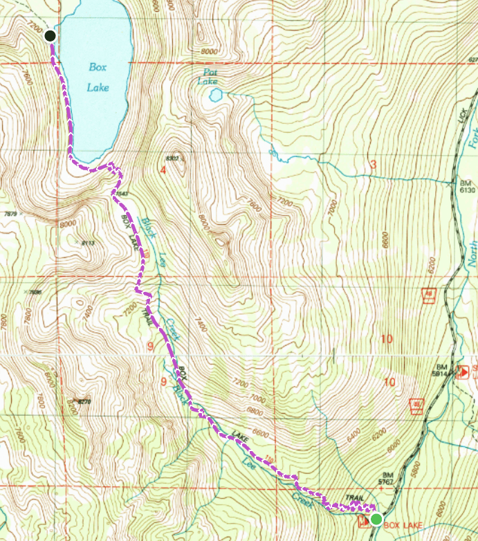
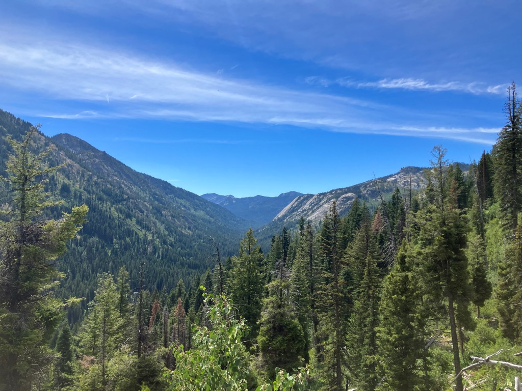
From the trailhead, Box Lake Trail enters the Payette National Forest and quickly ascends, alternating between switchbacks and steep, rocky sections. Luckily, this is the most-well shaded section on the whole route, and the immediate elevation gain isn’t so daunting. At four-tenths of a mile, the trail runs parallel to Black Lee Creek, which was still trickling when we visited in mid-August. Starting here, shade is intermittent as the trail travels sporadically in and out of a wildfire burn scar, but excellent views of the Lick Creek watershed open up behind you.
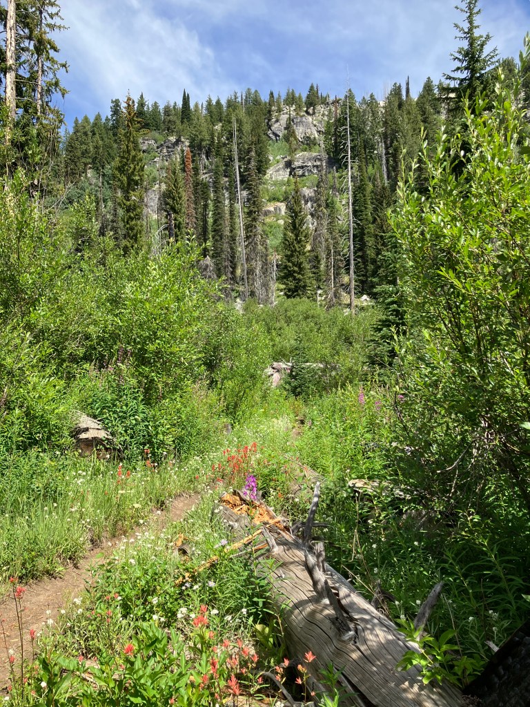
The ascent continues rather strenuously throughout the first mile, gaining over 800 feet before leveling out in a scenic valley. Here, the first evidence of the wildflower bonanza presents itself, in the form of clearings completely filled with five-foot tall fireweed. Mere steps beyond that, we found the corridor pictured below, covered with more fireweed, rhexia-leaf paintbrush, big-pod mariposa lilies, and common yarrow. At every turn, we found more flowers, growing more robustly and densely than I’ve ever seen outside of a botanical garden or nursery. The trail remains flat for about a half mile, roaming though meadows, marshes, and across the creek several times. At around 1.5 miles, the trail starts to side-hill up the sloping drainage and gains elevation steadily.
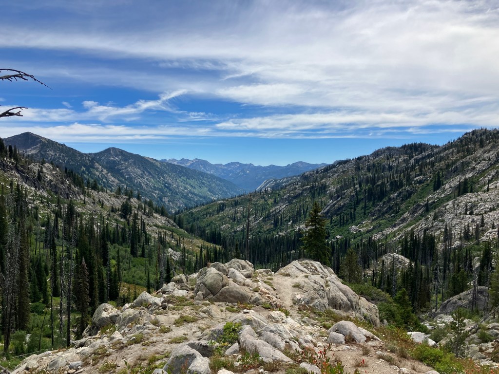
Around the two mile mark, you’ll leave the forest once again and begin ascending more intensely among rocky slopes. While some well-placed switchbacks ease the stress on your legs, unfolding views of the Black Lee Creek watershed behind you are the true motivator on this section. Even in this craggier, rougher terrain, the wildflowers are not just surviving, but thriving in all directions. We even saw a small patch of snow hanging on for dear life in a shady crux of the unnamed peak to the west.
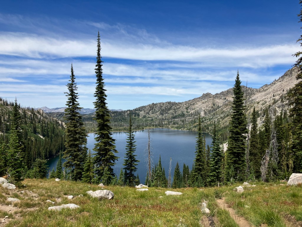
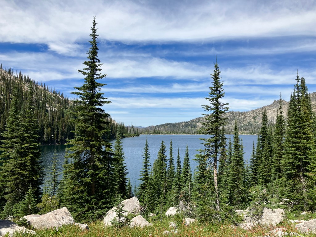
Just after 2.5 miles, the trail flattens as you crest the saddle that separates Black Lee Creek and Box Creek. While you may assume that the wildflower population would decline in this more sub-alpine biome, you would be remarkably incorrect. In fact, we saw more flower diversity here than anywhere else on Box Lake Trail. The meadow pictured below is crisscrossed with marshy channels, tangled up like branches in a flood, creating a wet ecosystem that fosters an absurd amount of color that I desperately wish showed up the zoomed-out photos better. You can find my favorite wildflower here – mountain bog gentian, a bell-shaped blossom that is often a deep, rich blue, reminiscent of the football field of my alma mater.

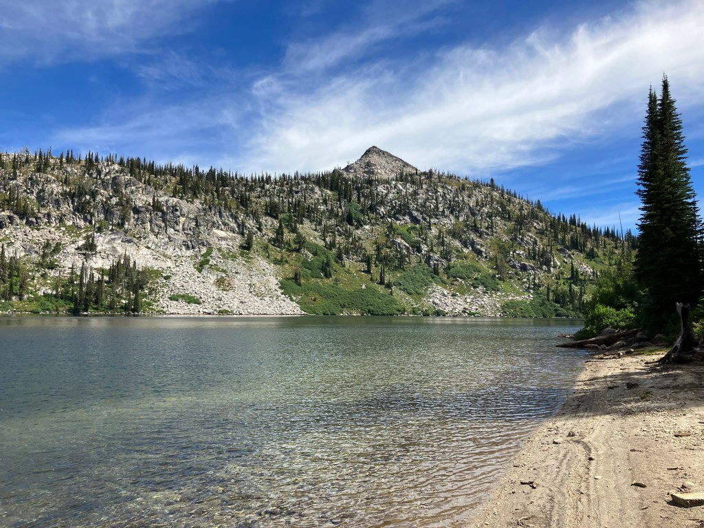
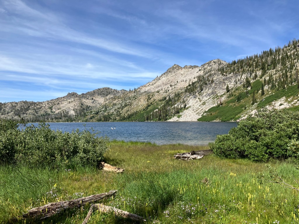
If you’re under the impression that the views can’t improve from this point, you are, unfortunately (fortunately?), very wrong again. At 3.0 miles, just beyond the meadow, Box Lake appears below you, shining like a jewel. To the lakeshore, it’s a half-mile descent that drops a quick 375 feet. If you have bad knees, you’ll want to take it easy here – a combination of roots, rocks, and steep slopes make it arguably more difficult to descend this section than ascend on the return leg. However, once you reach the lake, you’ll be rewarded with a gorgeous sandy beach that is perfect for sitting, snacking, or swimming (no joke, I had to create a “beach” tag just for this post). Excellent backpacking sites dot the southern and western sides of the lake for those looking to extend their trip.
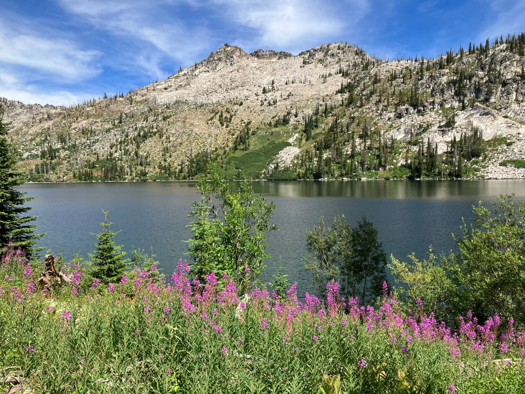
I’d highly recommend hiking along the western edge of Box Lake, where the trail again alternates between pine forests and wildflower-strewn clearings. At about 4.1 miles in, we found another beach that was more secluded from the groups of backpackers and offered a quiet spot to eat snacks, rest, and filter drinking water. If you’d like to continue down Box Lake Trail, it dead-ends about a mile later at Crestline Trail, a major north-south route in the Salmon River Mountains. We ventured to one of the nearby Sisters Lakes, but the off-trail scramble over deadfall wasn’t worth repeating. Once you’re ready to head back to the trailhead, simply retrace your steps and return the way you came.
Trail Stats
- Season: June to October
- Difficulty: Hard to Strenuous
- Type: Out-and-back
- Surface: Single track dirt, rock
- Distance: 8.4 miles
- Starting elevation: 5,688 feet
- Elevation gain: 2,250 feet
My Rating
I think this trail would’ve warranted five stars without the explosion of mid-August wildflowers we experienced, so this rating is a no-brainer. This might even become my #1 suggestion for people looking for a lake hike in McCall.
How to Get There
The drive to Box Lake Trail takes you up the beautiful Lick Creek Drainage, which is dotted with trailheads on both sides of the road as you ascend into the Salmon River Mountains. I haven’t written about other hikes here yet, but I’ve built a bridge on Duck Lake Trail with Idaho Trails Association and checked out the nearby Summit Lake on my way back. You could spend days or weeks hiking and backpacking the various trails along this route, and I’m sure I’ll return soon now that I know how great Box Lake is.
Here is the step-by-step navigation to the trailhead from intersection of Highway 55 and Deinhard Lane (the first stoplight when approaching McCall from the south), or use these steps:
- From Highway 55 northbound, turn right onto Deinhard Lane and continue for 0.5 miles
- Turn left onto S Samson Trail – keep in mind the speed limits are always 25mph unless otherwise posted in McCall city limits
- After 0.9 miles, continue straight as S Samson Trail becomes Spring Mountain Ranch Blvd
- After 1.3 miles, turn right onto Lake Street, which eventually becomes Lick Creek Road/NF-48
- The pavement ends shortly after passing Rowland Pond on the east side of Little Payette Lake
- Continue on Lick Creek Road/NF-48 for 12.4 miles to the trailhead on the left – there is parking for about fifteen vehicles on either side of the road
The road is gravel and rock for approximately eight miles, but is passable by all passenger vehicles, despite occasional potholes and washboarded sections. Drivers of lower-slung sedans will want to exercise extra caution.
Preparation
Payette National Forest
McCall Ranger District
(208) 634-0400
Maps & Publications
Here are the need-to-know details for hiking to Box Lake:
- This is black bear country – carry personal protection and know what to do in an encounter (here is a handy guide from the Humane Society of the United States for black bears)
- The initial ascent to the saddle above Box Lake and the descent to the lake have steep and rocky sections, but are suitable for children and dogs
- There are a few creek crossings, some of which are bridged with downed logs; some smaller ones require hopping across strategically-placed rocks
- There are numerous sources to pump and filter water from
- Route-finding is not necessary at any point on this trail
- The trail is about a 50/50 mix of shaded and exposed – protect yourself from the sun as needed
- Most of the elevation gain occurs at the beginning of the hike, with the rest occurring after leaving Box Lake’s shore on the return leg – plan accordingly and understand your own abilities
- Backpackers will find several great campsites along the southern and western edges of the lake
- Be respectful to other trail users and Leave No Trace!
Other Useful Resources
- Downloadable GPX track via AllTrails
- Topographical map via Natural Atlas
- The Hiker’s Guide: McCall and Cascade by Scott Marchant
- Trails of Western Idaho by Margaret Fuller
