It’s hard to believe that southern Idaho’s hiking season is already coming to an end, but with early snowfall and perpetual sub-40° temperatures on the horizon, I can’t imagine I’ll complete many trail miles from now until next spring. Like most endings, it’s bittersweet, as it ushers in a new, promising ski season, but nevertheless, I’m wistful that I won’t visit more alpine lakes or fire lookout towers in 2022. I typically rent snowshoes at least once a year and embark on a frozen trek – perhaps I’ll write about that sometime this winter. That being said, I was still able to squeeze in a blog-worthy hike as the first snowflakes fell, to one of my very favorite places in Oregon’s Owyhee Canyonlands – Juniper Gulch.
On the Trail
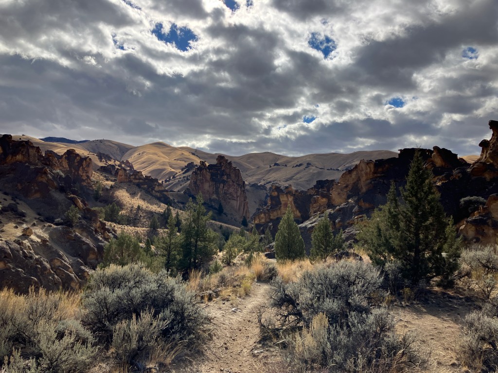
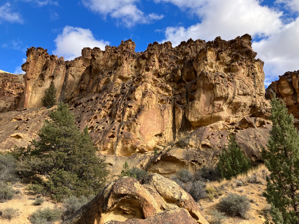
Juniper Gulch is part of the larger Leslie Gulch landscape – a well known Area of Critical Environmental Concern in far eastern Oregon near Owyhee Reservoir. The geology here is national monument-worthy; hoodoos tower over vertical gulches, wind and ice-carved “honeycombs” create raptor perches in rock walls, dry creek beds wind through channels reminiscent of subway tunnels. From the trailhead, it’s difficult to see the wonders ahead of you, which are all the more rewarding each time you stumble upon them. From the small parking area, descend to a dry arroyo and cross it, staying straight north into a ravine lined with tall red rocks and bushes. You’ll immediately understand why some compare this environment to southern Utah’s national parks.
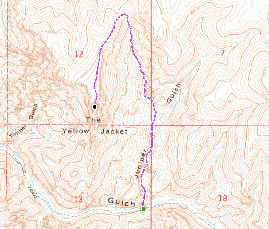
The hiking surface alternates between dry creek bed and dirt single track – stay out of the creek bed where possible to avoid ecological damage. Right away, you’ll pass a huge rock overhang on the left. If you have young kids (or you’re just a rock nerd like I am) this makes a great first stopping point. For the first 0.6 miles, you can wander without deviating too far, as the tight canyon prevents a departure from the route. At 0.65 miles, the gulch forks – the left side is not passable. The right side is overgrown and tough to navigate, but will take you forward. The best option is to look for the steep trail ascending the hill between the forks – this takes you up onto the spine between the two major gullies in Juniper Gulch.

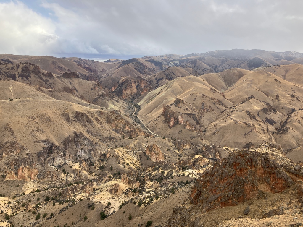
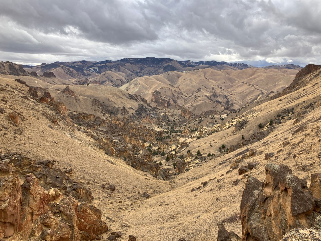
From this central ridge, the view unfolds all around you. As shown below, you can see the top of Juniper Gulch to the northwest, where you’ll hike to access the summit the Yellow Jacket. To the right, another arm of the gulch curves up and to the northeast, full of it’s own geologic spectacles. Behind you, hoodoos and other massive formations loom over the lower reaches of the gulch. Everywhere you look, the destructive force of nature is omnipresent – slowly, yet unyieldingly battering the earth to create and consume more of this alien scenery. It’s a great place to ponder geologic time and humanity’s relatively imperceptible impact on this planet and her environments.
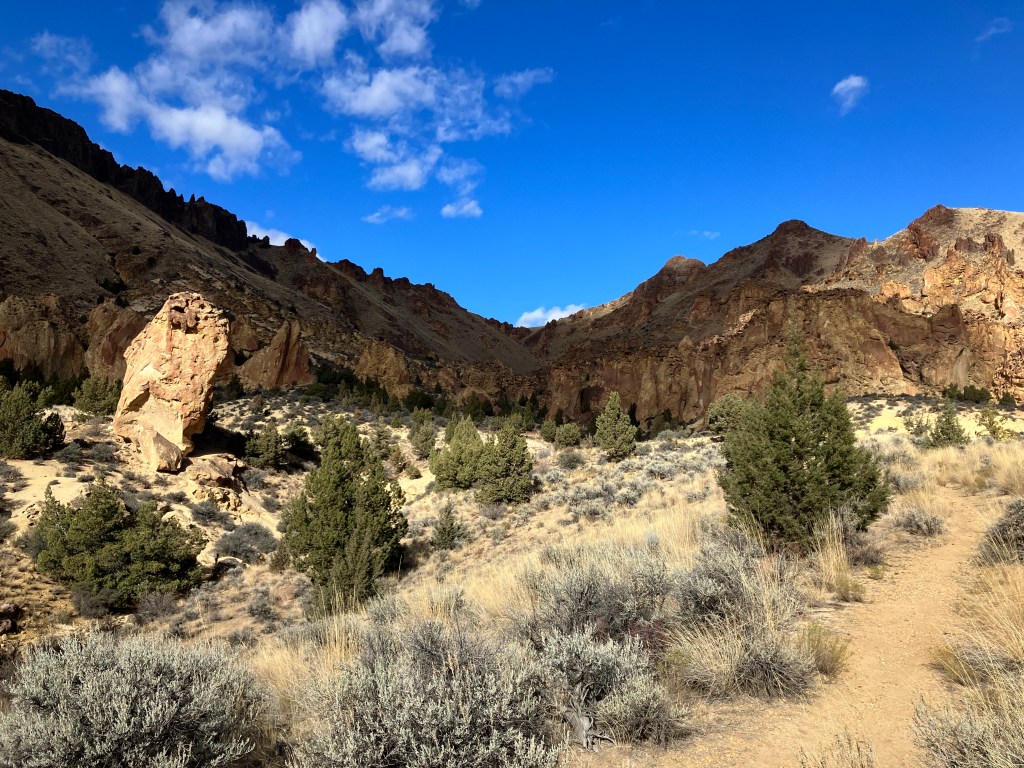
When you’re done having an existential crisis, continue along the ridge, looking for a trail down to the left. This will take you down to the creek bed of the west fork, where you’ll immediately start ascending again amongst balanced boulders and loose, sandy hills. If you have young kids or dogs, you may want to stop on the ridge and venture off to the sides rather than continuing, as it gets continually more difficult and there is plenty to explore in the vicinity. Ahead on the trail, some of the most impressive honeycomb formations will be high to your right on the castle-like formation below.
Looking forward, you’ll see the increasingly steep route to the top of the gulch. Continue climbing cautiously, as there are several places where even the best hiking boots will struggle to grip. The final push to the saddle is short but very arduous – if you need motivation, stop and turn around to look at the gulch and all of it’s marvels from far above. Beyond it, the ancient caldera of Mahogany Mountain rises 6,526 feet above the landscape, where 15.5 million years ago, an eruption created the rhyolite and tuff that has since been sculpted into the badlands of the Owyhees.

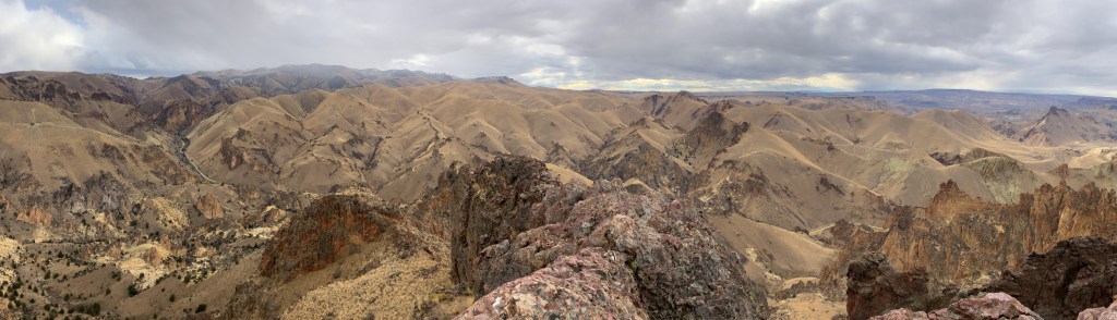
At the top of the saddle, there are some flat places to rest and take pictures with the full gulch in view. When you’re ready, look for a use trail that continues up the hill to the southwest (your right when looking back at the gulch) and follow it up onto the high ridge. As you hike south, there is a near-vertical drop into the gulch on the left, but the right side is a gently-sloping hill covered in grass and sagebrush. The trail comes and goes, but’s it easy enough to follow without maps or technology. At approximately 2.4 miles, avoid a false summit on the left. Within the next quarter mile, cathedral-like Timber Gulch comes into view down to the right. Be careful if you venture near the edge – it is a 1,300 foot drop.
The short scramble to the summit of the Yellow Jacket finally becomes apparent at mile 2.5. You’ll want to approach from the right (west) when viewing it. There is only one exposed step on the scramble, but it is a dangerously long fall and requires steady hands and focus. If you are not comfortable scrambling, do not attempt to go further. Once past it, it’s a few easy moves to the flat summit, where 4-5 people can sit comfortably and enjoy the views. Once you’re done taking it in, return the way you came. DO NOT attempt to down climb further south on the ridge – you will end up cliffed out.
Trail Stats
- Season: Year-round depending on snow/rainfall
- Difficulty: Hard
- Type: Out-and-back
- Surface: Single track dirt, dry creek bed, sand, rock
- Distance: 5.3 miles
- Starting elevation: 3,424 feet
- Elevation gain: 1,400 feet
My Rating
All you need to know is that I come here once a year to hike either Juniper Gulch, Upper Leslie Gulch, Dago Gulch, or Timber Gulch. All of them are spectacular, even the second, third, and fourth times. Come in the springtime when the grass is green and the wildflowers are in bloom, or in the winter, when the crowds are gone and snow flanks the higher peaks in the area.
How to Get There
From Boise, the drive takes a little under two hours on high-quality dirt roads that any vehicle type can use. The three-mile descent into the gulch is almost as spectacular as the hiking, and the road narrows to one lane in places, so be prepared to drive slowly. Here are the step-by-step directions from the flying Y in Boise, or use these steps:
- Travel west on Interstate 84 for 15.3 miles
- Take exit 33 on the right for Karcher Road/Midland Blvd/ID-55
- At the top of the exit, turn right onto W Karcher Road/ID-55
- Continue on ID-55 for 16.7 miles
- Turn left onto US-95 – the Chevron on the right is the last place to stop if you need additional water or supplies
- Continue on US-95 for 19.1 miles to the bottom of a hill – slow down and look for the dirt road on the right (north)
- Turn right onto McBride Creek Road
- At 2.5 miles, the road curves to the left (west) – avoid minor roads straight or to the right
- Continue 6.2 miles to the small ranch community of Rockville
- Turn right onto Succor Creek Road and continue 0.3 miles across the valley
- Turn right again to remain on Succor Creek Road
- Continue 1.5 miles to a three-way intersection with a BLM sign pointing west towards Leslie Gulch
- Turn left (west) onto Leslie Gulch Road and continue 10.3 miles to the trailhead on the right – there is parking for a few vehicles
If you’re coming from points east, here is the step-by-step navigation from Jordan Valley, Oregon, or follow these steps:
- Travel north on US-95 for 18.2 miles
- Turn left onto Succor Creek Road and continue for 8.5 miles to the small ranch community of Rockville, avoiding minor side roads
- Turn left to stay on Succor Creek Road and continue 0.3 miles across the valley
- Follow the directions above starting from #11

Preparation
Bureau of Land Management
Vale District Office
(541) 473-3144
Upper Leslie Gulch Wilderness Study Area
Oregon Natural Desert Association
Leslie Gulch
Here are the need-to-know details for hiking to the Yellow Jacket:
- This area is home to coyotes, bighorn sheep, pronghorn antelope, birds of prey, snakes, and more – be respectful to local flora and fauna
- Wear sturdy hiking shoes or boots for the off-trail hiking and scrambling where the ground is uneven, rocky, and unstable
- Bring your own water – there is no reliable water source in the area
- Be cautious around the sheer drops along the ridge and on top of the Yellow Jacket
- There is no shade once you leave the main fork of Juniper Gulch – protect yourself from the sun as needed and expect warm temperatures to feel hotter in the direct sunlight
- Dispersed camping is not allowed in the Area of Critical Environmental Concern – if you wish to extend your trip overnight, Slocum Creek Campground features 13 free, unreserved campsites and a boat ramp on Owyhee Reservoir just 3.5 miles west of the trailhead
- Be respectful to other trail users and Leave No Trace!
Other Useful Resources
- Downloadable GPX track via AllTrails
- Topographical map via CalTopo
- The Owyhee Canyonlands – An Outdoor Adventure Guide by Steve Stuebner and Mark Lisk

2 responses to “Juniper Gulch to the Yellow Jacket”
We were in Zion National Park in June and I swear some of the Owyhee Mountain terrain reminds me of what we saw in Zion. Best part of the Owyhee’s is very few people go out there and explore. I will have to find this trail as there are no hiking maps of the Owyhee’s at all. The USGS Store has some pretty good options for 1:24,000 maps of these areas but you’ll have to mark the trails on there.
LikeLiked by 1 person
Thanks for the comment! I agree – the Owyhee wilderness is little slice of southern Utah in Idaho and Oregon. The trails in this area are quite easy to find, as there’s only one road in and out of the canyon, and you’ll typically see other hikers parked at the trailheads. If you’re using apps like AllTrails or Gaia, they’re even easier to find/navigate. The great thing about Juniper Gulch is that you can explore off trail and find incredible geology everywhere you look.
LikeLike