I’ve already logged almost one hundred and sixty miles on trails in 2025, and I’ve been waiting for a stand-out hike to write about. There have been some contenders that will probably make the “2025 Almost Blogworthy” post, but nothing really blew me away until last weekend’s trip to Hidden Lake and Hard Creek Lake. It feels necessary to mention now that the pictures in this post were taken on my iPhone SE3 and have not been edited in any way. The scenery truly is that good – and not just on part of this hike – on the entire length. As an added bonus, you don’t have to work very hard to get to either lake – at seven miles and one thousand feet of total gain, the ratio of difficulty to scenery has never been better.
On the Trail
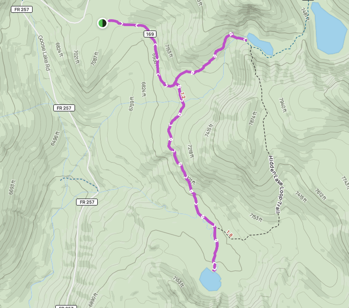
The hike begins at Hard Creek Guard Station, about fifteen miles north of the base lodge of Brundage Mountain Resort in McCall. The trail is a double out-and-back, with two legs each heading to a lake, both of which allow dirt bikes. We hiked in late June after an average snow year for central Idaho and ran into some lingering snow on the trail in the thickest, shadiest parts of the forest near Hidden Lake. In years with longer or wetter winters, this area may not be accessible until mid-July. We lucked out with perfect weather – high sixties, intermittent cloud cover, and a gentle breeze. Much of this trail is exposed, so plan accordingly if rain is in the forecast.
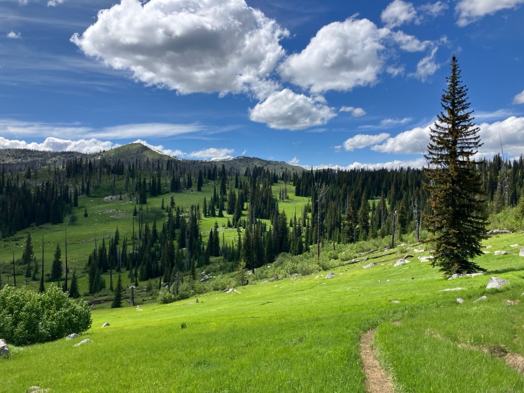
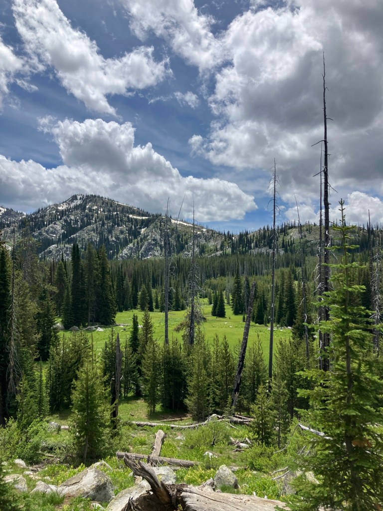
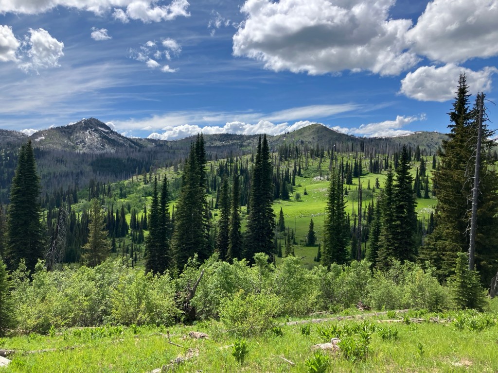
The trail heads east from a small parking area, entering a vibrant meadow almost immediately. I’d wager that within a few weeks, wildflowers will be growing vigorously among the grass. The views improve as the trail turns south and descends a small slope. You’ll hike through a series of meadows, each seemingly greener than the last. Between them, strips of pine and willow grow along small creeks that can be stepped over easily. The trail hugs the hillside, rarely gaining or losing more than a few feet at a time.
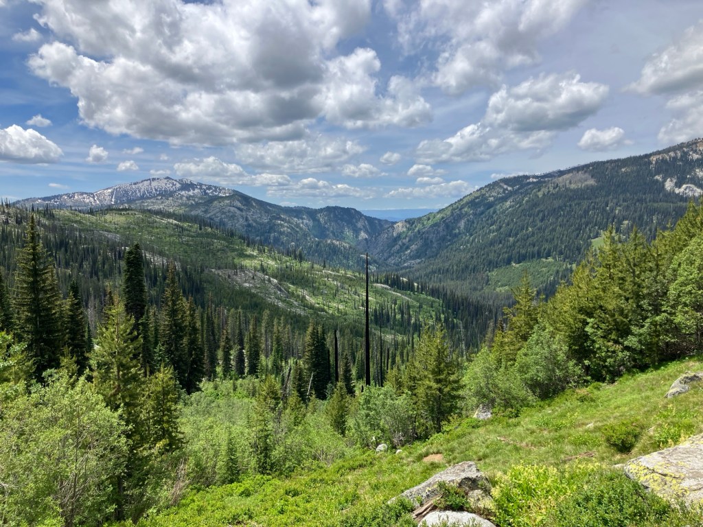
At just under a mile, you’ll reach an intersection – turn left for Hidden Lake Trail, or continue straight on Hard Creek Basin Trail. The sign is easy to miss, as it’s nailed to a tree perpendicular to the trail. Those interested in a shorter hike can choose one of the two lakes for an easy four or five-mile trek. We opted for Hidden Lake first. Shortly after the intersection, there’s a shallow crossing of Hard Creek with some conveniently placed rocks to hop across. Beyond this, the trail begins to undulate more, with brief steep sections. Interesting geology and increasingly good views down the Hard Creek drainage keep things exciting. At 1.8 miles, you’ll reach the top of a descent into a meadow I’d describe as “perfect for frolicking in.”
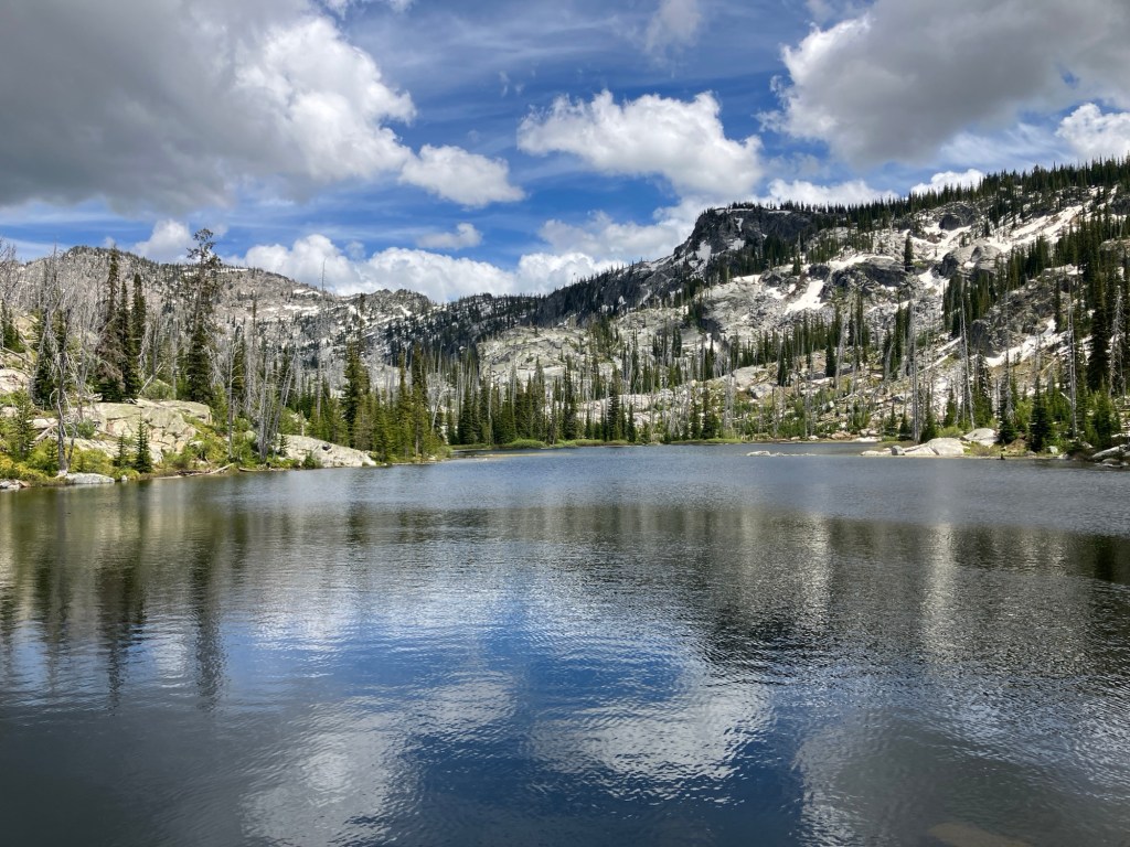
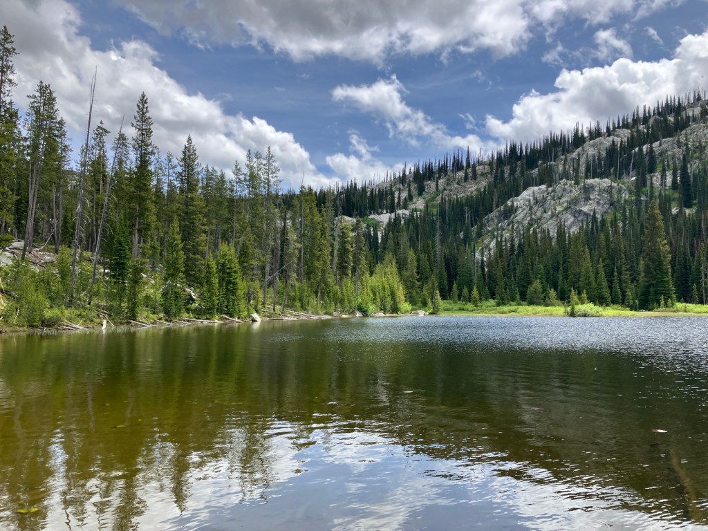
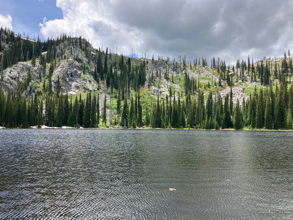
The trail descends the rocky hillside and enters the meadow, which seems like a prime spot for wildlife viewing. It’s about a half-mile to a crossing of the outlet creek of Hidden Lake – it’s wide, but shallow, and requires getting wet. This section of trail is where snow lingered the most, but we hiked through or around it without much trouble. Another quarter-mile of gentle uphill from the creek, the trail dead-ends at the lake, framed handsomely by granite and pine. We planned to eat lunch here but heard the loud crack of a heavy wild animal breaking a tree branch in the vicinity. We decided to keep moving. Those interested in backpacking here will find several great spots along the shore.
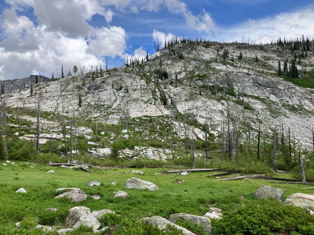
It’s 1.6 miles back to the intersection from Hidden Lake. Once you turn right onto Hard Creek Basin Trail, it’s a quick one-mile and four hundred feet of elevation gain to Hard Creek Lake. The ascent travels through yet another picturesque meadow, dotted by rocks and dead snags from a 1994 wildfire. We saw several young marmots and scared a large spruce grouse along this stretch. Near the lake outlet, Hard Creek overflows onto the trail in early summer – be careful navigating the mud and slippery rocks.
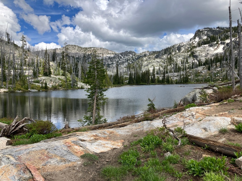
At 5.2 miles, Hard Creek Lake comes into view. I’ll let the pictures speak for themselves – just know that this immediately jumped into our top five alpine lakes. Another half mile of hiking would’ve brought us to Upper Hazard Lake, but there was just enough snow that it wasn’t worth the effort. We’ll return another time and hike there from the Hazard Lake Trailhead. We spent about thirty minutes here, just enjoying the views and watching clouds roll in and out. Before leaving, we chatted with a family of backpackers who’d established an excellent campsite north of the trail near the creek.
Once ready to depart, we retraced our steps down Hard Creek Basin Trail and back to the car. We saw one other group of hikers on our way out. We hiked on a Friday, and I’d assume the trail is slightly busier on Saturday and Sunday.
Trail Stats
- Season: Mid-June to October
- Difficulty: Moderate
- Type: Single-track
- Surface: Dirt, rock
- Distance: 7 miles
- Starting elevation: 7,047 feet
- Elevation gain: 1,000 feet
My Rating
As stated earlier, this trail is an uncommon combination of easy and stunningly beautiful. I’d recommend it to hikers of all ages and abilities. I’ve realized now that I don’t ever rate anything I write about less than four stars (maybe I should switch to a binary system), but this is perhaps the easiest five-star rating I’ve given. On second thought, maybe I’ll expand the scale and give this a six…
How to Get There
This is one of the rare trails where the drive is nearly as beautiful as the hike. As an added bonus, the gravel road from Brundage to the trailhead was recently regraded and is suitable for any vehicle type. Aside from a few potholes on the stretch along Goose Lake, the road is in great condition. Be sure to watch for a large, unnamed waterfall on the righthand side of the road about 5.2 miles after Goose Lake.
Here is the step-by-step navigation from the bend in Highway 55 in downtown McCall, or use these steps:
- Continue west on Highway 55 for 5.6 miles
- Turn right onto Goose Lake Road towards Brundage Mountain Resort
- After 3.6 miles, continue slight left to stay on Goose Lake Road, which turns to well-graded gravel and remains two lanes
- Continue on Goose Lake Road for 15.2 miles, passing Brundage Reservoir, Goose Lake, and several other trailheads as you ascend
- After rounding a 180-degree right-hand corner, round a left-hand corner and look for a smaller dirt road on the right
- Turn right onto the minor dirt road, which is also in good condition
- The trailhead and several campsites are about 200 yards ahead on the left
There is a mobile National Forest guard station at the trailhead. It was unmanned when we hiked here in late June 2025 but appears to be in sporadic use. The trailhead has amenities for horseback riders and dirt bikers to unload their trailers, but doesn’t have a bathroom (there are several on the drive). There were some shady sites left of the trailhead that would be excellent for car camping.
Preparation
Payette National Forest
New Meadows Ranger District
(208) 347-0300
Maps & Guides
Here are the need-to-know details for hiking to Hidden Lake and Hard Creek Lake:
- This is black bear country – carry personal protection and know what to do in an encounter (here is a handy guide from the Humane Society of the United States for black bears)
- The entire trail is suitable for children and dogs
- There are a few creek crossings, none of which are bridged – only one requires getting wet
- There are numerous sources to pump and filter water from
- Route-finding is not necessary at any point
- Most of the trail is exposed – protect yourself from the sun as needed
- Backpackers will find at least one good campsite at each lake
- Be respectful to other trail users and Leave No Trace!
Other Useful Resources
- Downloadable GPX track via AllTrails
- Topographical map via CalTopo
- The Hiker’s Guide: McCall and Cascade by Scott Marchant

2 responses to “Hidden Lake and Hard Creek Lake”
Not sure how I found your site, but glad I did. I was searching ‘Exploring the Boise National Forest’ and somehow stumbled upon your hikes. I’m an avid outdoorsman, hiker, single track mountain biker (well used to be) and hunter. I try to get our kids on the trail as much as I can. The problem is finding these trail. I really wish Idaho City had more trails to offer! I know of all the hikes you’ve presented because I study topographic maps like people read books. The information and pictures you show here are exactly what I need. AllTrails is a little disappointing in my opinion (they actual erased my bio last month after I logged all the trails I’ve done in Idaho, Oregon, Washington, Wyoming, Montana, Utah and Colorado over the last twenty years). Not sure why. I’m going to try this hike next time we are up in McCall and use your site as a reference. I also gave my contact to the Idaho Trails Association last year to see if they need help with anything but haven’t heard anything. We live in the Treasure Valley and both of us work in the Boise area. Cheers.
LikeLiked by 1 person
I’m glad you found me! This is a good creative outlet for me that I share with friends and family, so it’s nice that you were able to find it by searching online – I must be doing something right. I’ve had issues with AllTrails too and typically have Gaia downloaded as a backup out on the trails. Hidden Lake/Hard Creek Lake is a truly spectacular hike – you won’t be disappointed. As for ITA – you may need to sign up for the emailed newsletter on their website to get monthly updates. I think they’ll automatically start sending it to you if you become a member by making a $25 donation. Cheers!
LikeLike